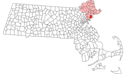
Salem, Massachusetts
| Salem, Massachusetts | |||
|---|---|---|---|
| — City — | |||
 |
|||
|
|||
| Nickname(s): The Witch City | |||
 |
|||
| Coordinates: | |||
| Country | United States | ||
| State | Massachusetts | ||
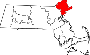
| County | Essex | ||
| Settled | 1626 | ||
| Incorporated | 1629 | ||
| A City | 1836 | ||
| Government | |||
| - Type | Mayor-council city | ||
| - Mayor | Kimberley Driscoll | ||
| Area | |||
| - Total | 18.1 sq mi (46.8 km2) | ||
| - Land | 8.1 sq mi (21.0 km2) | ||
| - Water | 10.0 sq mi (25.8 km2) | ||
| Elevation | 9 ft (3 m) | ||
| Population (2007) | |||
| - Total | 40,922 | ||
| - Density | 5,052.1/sq mi (1,948.7/km2) | ||
| Time zone | Eastern (UTC-5) | ||
| - Summer (DST) | Eastern (UTC-4) | ||
| ZIP code | 01970 / 01971 | ||
| Area code(s) | 351 / 978 | ||
| FIPS code | 25-59105 | ||
| GNIS feature ID | 0614337 | ||
| Website | www.salem.com | ||

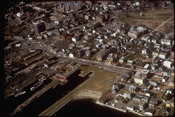
Salem is a city in Essex County, Massachusetts, United States. The population was 40,407 at the 2000 census. It and Lawrence are the county seats of Essex County.[1] Home to Salem State University, the Salem Willows Park and the Peabody Essex Museum, Salem is a residential and tourist area which includes the neighborhoods of Salem Neck, The Point, South Salem and North Salem, Witchcraft Heights, Pickering Wharf, and the McIntire Historic District (named after Salem's famous architect and carver, Samuel McIntire).
Salem was one of the most significant seaports in early America. It has the first National Historic Site designated by Congress, Salem Maritime National Historic Site, which protects Salem's historic waterfront.
Featured notably in Arthur Miller's The Crucible, much of the city's cultural identity is reflective of its role as the location of the Salem Witch Trials of 1692: Police cars are adorned with witch logos, a local public school is known as the Witchcraft Heights Elementary School, the Salem High School football team is named The Witches, and Gallows Hill, a site of numerous public hangings, is currently used as a playing field for various sports.
Tourists know Salem as a mix of important historical sites, New Age and Wiccan boutiques, and kitschy Halloween or witch-themed attractions.
Contents |
History
Salem was founded at the mouth of the Naumkeag river in 1626 at the site of an ancient Native American village and trading center (it was originally called Naumkeag and was renamed Salem three years later) by a company of fishermen from Cape Ann led by Roger Conant, and incorporated in 1629. Conant’s leadership had provided the stability to survive the first two years, but he was immediately replaced by John Endicott, one of the new arrivals, by order of the Dorchester Company. Conant graciously stepped aside and was granted 200 acres of land in compensation. These “New Planters” and the “Old Planters” agreed to cooperate, in large part due to the diplomacy of Conant and Endicott. In recognition of this peaceful transition to the new government, the name of the settlement was changed to Salem, a corruption of the Hebrew word ‘shalom.[2]
Naumkeag was first settled in 1626 by the Dorchester Company with Roger Conant as Governor. That settlement was located east of the present day Salem commuter rail station.
A year later, Governor John Endicott arrived in Naumkeag and a patent was solicited by the Massachusetts Bay Company in England. Endicott moved the Great House from Cape Anne reassembling on what is now Washington Street north of Church Street. And a year later, the Massachusetts Bay Charter was issued creating the Massachusetts Bay Colony with Thomas Craddock as Governor and Endicott as a Governor's Assistant. A challenge to Endicott's authority in Naumkeag arose in London and was settled within the Massachusetts Bay Company. One week later, Governor John Winthrop was elected Governor and John Endicott was re-elected Governor's Assistant, followed by the Great Puritan Migration/Fleet of 1629/1630. Endicott's greeting of Winthrop is the subject of a plaque on the Boston Common.
In 1639, his was one of the signatures on the building contract for enlarging the meeting house in Town House Square for the First Church in Salem. This document remains part of the town records at City Hall. He was active in the affairs of the town throughout his life. In 1679, he died at the age of 87. Salem originally included much of the North Shore, including Marblehead. Most of the accused in the Salem witch trials lived in nearby 'Salem Village', now known as Danvers, although a few lived on the outskirts of Salem. Salem Village also included Peabody and parts of present-day Beverly. Middleton, Topsfield, Wenham and Manchester-by-the-Sea, too, were once parts of Salem. One of the most widely known aspects of Salem is its history of witchcraft allegations, which started with Abigail Williams, Betty Parris, and their friends playing with a Venus glass and egg. Salem achieved further legal notoriety as the site of the Dorothy Talbye trial, where a mentally ill woman was hanged for murdering her daughter, because at the time the Massachusetts common law made no distinction between insanity and criminal behavior.[3]
On February 26, 1775, patriots raised the drawbridge at the North River, preventing British Colonel Alexander Leslie and his 300 troops of the 64th Regiment of Foot from seizing stores and ammunition hidden in North Salem. A few months later, in May 1775, a group of prominent merchants with ties to Salem, including Francis Cabot, William Pynchon, Thomas Barnard, E.A. Holyoke and William Pickman, felt the need to publish a statement retracting what some interpreted as Loyalist leanings and to profess their dedication to the Colonial cause.[4]
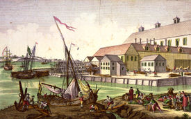
During the Revolution, the town became a center for privateering. Although the documentation is incomplete, about 1,700 Letters of Marque, issued on a per-voyage basis, were granted during the American Revolution. Nearly 800 vessels were commissioned as privateers and are credited with capturing or destroying about 600 British ships.[5] By 1790, Salem was the sixth largest city in the country, and a world famous seaport—particularly in the China trade. Codfish was exported to the West Indies and Europe. Sugar and molasses were imported from the West Indies, tea from China, and pepper from Sumatra. Salem ships also visited Africa, Russia, Japan and Australia. During the War of 1812, privateering resumed.
Prosperity left the city with a wealth of fine architecture, including Federal style mansions designed by one of America's first architects Samuel McIntire, for whom the city's largest historic district is named. These homes and mansions from Colonial America now comprise the greatest concentrations of notable pre-1900 domestic structures in the United States.
This wealth of architecture in Salem can be directly attributed to the Old China Trade, which was ongoing for years with America and Great Britain. The neutrality of the United States was tested during the Napoleonic Wars. Both Britain and France imposed trade restrictions in order to weaken each others' economies. This also had the effect of disrupting American trade and testing the United States' neutrality. As time went on, harassment by the British of American ships increased by the British Navy. This included impressment and seizures of American men and goods. After the Chesapeake Leopard Affair, Thomas Jefferson was faced with a decision to make regarding the situation at hand. In the end, he chose an economic option: the Embargo Act of 1807 and Thomas Jefferson basically closed all the ports overnight, putting a little damper on the seaport town of Salem. The embargo of 1807 was the starting point on the path to the War of 1812 with Great Britain.
Incorporated as a city on March 23, 1836 [6], Salem adopted a city seal in 1839 with the motto "Divitis Indiae usque ad ultimum sinum", Latin for "To the farthest port of the rich Indies." Nathaniel Hawthorne was overseer of the port from 1846 until 1849. He worked in the Customs House near Pickering Wharf, his setting for the beginning of The Scarlet Letter. In 1858, an amusement park was established at Salem Willows, a peninsula jutting into the harbor. It should be noted that up until the War of 1812, the port of Salem was a major center of trade in America.
But shipping declined throughout the 19th century. Salem and its silting harbor were increasingly eclipsed by Boston and New York. Consequently, the city turned to manufacturing. Industries included tanneries, shoe factories and the Naumkeag Steam Cotton Company. More than 400 homes burned in the Great Salem Fire of 1914, leaving 3,500 families homeless from a blaze that began in the Korn Leather Factory. The fire ripped into one part of the city, but historical places including City Hall and the historic concentration of Federal architecture on Chestnut Street were spared; the fire left mostly all of Salem's architectural legacy intact, which helped it develop as a center for tourism.
The book "The Salem-India Story" written by Vanita Shastri narrates the adventures of the Salem seamen who connected the far corners of the globe through trade. This period (1788–1845) marks the beginning of US-India relations, long before the 21st century wave of globalization. It reveals the global trade connections that Salem, Massachusetts, had established with faraway lands, which were a source of livelihood and prosperity for many.
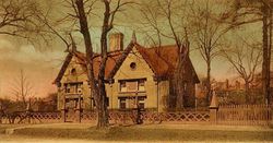
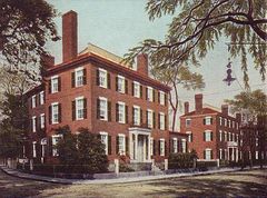 Peabody House, c. 1905 |
 Salem Harbor in 1907 |
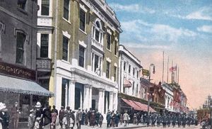
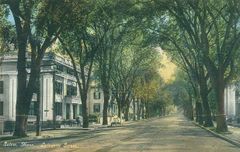 Lafayette Street in 1910 |
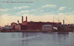 Naumkeag Mills, c. 1910 |
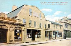 Roger Williams House (or The Witch House) c. 1910 |
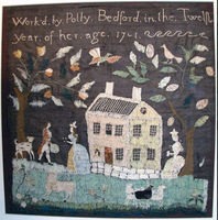 Sampler (needlework) made in Salem in 1791. Art Institute of Chicago textile collection. |
Geography and transportation

Salem is located at (42.516845, -70.898503).[7] According to the United States Census Bureau, the city has a total area of 18.1 square miles (46.8 km²), of which, 8.1 square miles (21.0 km²) of it is land and 9.9 square miles (25.8 km²) of it (55.09%) is water. Salem lies on Massachusetts Bay between Salem Harbor, which divides the city from much of neighboring Marblehead to the southeast, and Beverly Harbor, which divides the city from Beverly along with the Danvers River, which feeds into the harbor. Between the two harbors lies Salem Neck and Winter Island, which are divded from each othe by Cat Cove, Smith Pool (located between the two land causeways to Winter Island) and Juniper Cove. The city is further divided by Collins Cove, and the inlet to the North River. The Forest River flows through the south end of town as well, along with Strong Water Brook, which feeds Spring Pond at the town's southwest corner. The town has several parks, as well as conservation land along the Forest River and Camp Lion, which lies east of Spring Pond.
The city is divided by its natural features into several small neighborhoods. The Salem Neck neighborhood lies northeast of downtown, and North Salem lies to the west of it, on the other side of the North River. South Salem is south of the South River, lying mostly along the banks of Salem Harbor southward. Downtown Salem lies fifteen miles northeast of Boston, sixteen miles southwest of Gloucester and Cape Ann, and nineteen miles southeast of Lawrence, the other county seat of Essex County. Salem is bordered by Beverly to the north, Danvers to the northwest, Peabody to the west, Lynn to the southeast, Swampscott to the south, and Marblehead to the southeast. The town's water rights extend along a channel into Massachusetts Bay between the water rights of Marblehead and Beverly.
The connection between Salem and Beverly is made across the Danvers River and Beverly Harbor by three bridges, the Kernwood Bridge to the west, and a railroad bridge and the Essex Bridge, from the land between Collins Cove and the North River, to the east. Essex Bridge carries Route 1A across the river. Route 1A passes through the eastern side of the city, through South Salem towards Swampscott. For much of its length in the city, it is coextensive with Route 114, which goes north from Marblehead before merging with Route 1A, and then heading northwest from downtown towards Lawrence. Route 107 also passes through town, entering from Lynn in the southwest corner of the city before heading towards its intersection with Route 114 and terminating at Route 1A. There is no highway access within the city; the nearest highway access to Route 128 is along Route 114 in neighboring Peabody.
Several lines of the MBTA Bus service pass through the city. Salem has a station on the Newburyport/Rockport Line of the MBTA Commuter Rail. The railroad lines are also connected to an abandoned portion of the Springfield Terminal lines which lead into Peabody, and a former line into Marblehead has been converted into a bike path.
In 2006 Salem launched the Nathaniel Bowditch, a 92 Foot Salem Ferry powered by two twin turbo Caterpillar Inc. diesel engines, toping out at 36 knots makes the trip from Salem to the New England Aquarium or the Boston World Trade Center in just under an hour.
The nearest small airport is Beverly Municipal Airport, and the nearest national and international service can be reached at Boston's Logan International Airport.
Demographics
| Historical populations | ||
|---|---|---|
| Year | Pop. | %± |
| 1635* | 900 | — |
| 1765* | 4,427 | 391.9% |
| 1790 | 7,921 | 78.9% |
| 1800 | 9,457 | 19.4% |
| 1810 | 12,613 | 33.4% |
| 1820 | 12,731 | 0.9% |
| 1830 | 13,895 | 9.1% |
| 1840 | 15,082 | 8.5% |
| 1850 | 20,264 | 34.4% |
| 1860 | 22,252 | 9.8% |
| 1870 | 24,117 | 8.4% |
| 1880 | 27,563 | 14.3% |
| 1890 | 30,801 | 11.7% |
| 1900 | — | |
| 1910 | 43,697 | — |
| 1920 | — | |
| 1930 | — | |
| 1940 | — | |
| 1950 | — | |
| 1960 | — | |
| 1970 | — | |
| 1980 | — | |
| 1990 | 38,091 | — |
| 2000 | 40,407 | 6.1% |
| sources:[8] [9] | ||
As of the census[10] of 2000, there were 40,407 people, 17,492 households, and 9,708 families residing in the city. The population density was 4,986.0 people per square mile (1,926.1/km²). There were 18,175 housing units at an average density of 2,242.7/sq mi (866.3/km²). The racial makeup of the city was 85.37% White, 3.15% African American, 0.22% Native American, 2.00% Asian, 0.05% Pacific Islander, 6.74% from other races, and 2.47% from two or more races. Hispanic or Latino of any race were 11.24% of the population.
There were 17,492 households out of which 24.2% had children under the age of 18 living with them, 38.8% were married couples living together, 13.3% had a female householder with no husband present, and 44.5% were non-families. 34.9% of all households were made up of individuals and 11.5% had someone living alone who was 65 years of age or older. The average household size was 2.24 and the average family size was 2.95.
In the city the population was spread out with 20.2% under the age of 18, 10.4% from 18 to 24, 33.4% from 25 to 44, 21.9% from 45 to 64, and 14.1% who were 65 years of age or older. The median age was 36 years. For every 100 females there were 86.5 males. For every 100 females age 18 and over, there were 83.5 males.
The median income for a household in the city was $44,033, and the median income for a family was $55,635. Males had a median income of $38,563 versus $31,374 for females. The per capita income for the city was $23,857. About 6.3% of families and 9.7% of the population were below the poverty line, including 12.2% of those under age 18 and 7.9% of those age 65 or over.
Education
Salem State University is the largest state university in Massachusetts (note that State Universities are separate from the University of Massachusetts system), with 7,000 undergraduates and 2,500 graduate students; its campus comprises 108 acres (0.44 km2) and 33 buildings. It hosts a regular Speaker Series, featuring major invited speakers. It was originally founded as the Salem Normal School (for teacher training) in 1854, thanks to the efforts of Horace Mann who is considered the "Father of American Public Education."
Public elementary schools include the Bates, Bentley, Carlton, Horace Mann, Nathaniel Bowditch, Saltonstall and Witchcraft Heights schools. Collins Middle School, Nathaniel Bowditch School, and Salem High School are located on Highland Avenue. Private schools are also located in the city, including two independent, alternative schools, The Phoenix School and the Greenhouse, as well as the Salem Academy Charter School.
Salem also once had a very strong Roman Catholic school system. Once home to almost a dozen schools, the last school in the city, St. Joseph, has announced it will close in June 2009. St. James High School, St. Chretienne Academy, St. Chretienne Grammar School and St. Mary's School closed in 1971, St. James Grammar School closed in 1972, St. Thomas the Apostle School closed in 1973, St. Anne School closed in 1976, St. John the Baptist School closed in 1977 and St. Joseph High School closed in 1980.[11]
In late 2007 and early 2008, the city's public school system garnered regional and even national attention after officials announced a $4.7 million budget shortfall that threatened the jobs of teachers and other staff members. The Massachusetts General Court passed legislation, and residents raised enough money, that averted teacher layoffs. Several dozen support workers were still laid off.[12] Police were investigating what happened to the money in a search for criminal violations of the law.[13]
Tourism
Since the decline of the city's industrial base, tourism has become an increasingly important part of Salem's economy. Tourism based on the 1692 witch trials dates back to at least the first half of the 20th century, when dry goods merchant Daniel Low sold souvenir spoons with witch images. Such tourism expanded significantly in the 1970s, when the television comedy Bewitched filmed several episodes here.[14] Witch-related tourism expanded significantly in the 1990s, and the city added an official "Haunted Happenings" celebration during the October tourist season. In 2007, the city launched the Haunted Passport program which offers visitors discounts and benefits from local tourist attractions and retailers from October to April. The goal of the program is to get visitors to come back to Salem after Halloween and experience businesses that may not be directly tied to Halloween. Thousands watched in 2007 as Mayor Kim Driscoll started a new trend with a massive fireworks display that kicked off at 10:00 pm on Halloween.[15]
In recent years, tourism has been an occasional source of debate in the city, with some residents arguing the city should downplay witch tourism and market itself as a more upscale cultural center. In 2005, the conflict came to a head over plans by the cable television network TV Land to erect a bronze statue of Elizabeth Montgomery, who played the comic witch "Samantha" in the 1960s series Bewitched. A few special episodes of the series were actually filmed in Salem, and TV Land said that the statue commemorated the 35th anniversary of those episodes. The statue was sculpted by StudioEIS under the direction of brothers Elliott and Ivan Schwartz. Many felt the statue was good fun and appropriate to a city that promotes itself as "The Witch City", and contains a street named "Witch Way". Others objected to the use of public property for what was transparently commercial promotion. Some felt that the statue trivialized history by encouraging visitors to recall a sitcom rather than the tragic Salem witch trials. The statue was later vandalized with red spray-painted "X"s over the face and chest, and flags placed in the statue's hands.

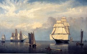
In 2000 the replica tall ship Friendship was finished and sailed to Salem Harbor, where she sits today. The Friendship is a reconstruction of a 171-foot (52 m) three-masted Salem East Indiaman trading ship, originally built in 1797, which traveled the world over a dozen times and returned to Salem after each voyage with goods from all over the world. The original was taken by the British during the War of 1812, then stripped and sold in pieces.
In 2006 with the assistance of a 1.6 million dollar grant [5] and hundreds of thousands provided by the City Of Salem, Kim Driscoll Mayor of Salem, launched The Nathaniel Bowditch, a 92 Foot Salem Ferry toping out at 36 knots makes the trip from Salem to Boston in just under an hour. Nathaniel Bowditch who born in Salem Massachusetts and had a home on North Street, at the intersection of Essex Street & Summer Street is considered the founder of modern maritime navigation with his book Bowditch's American Practical Navigator, first published in 1802, is still carried on board every commissioned U.S. Naval vessel. Click on the link to learn more on the schedule of the Salem Ferry to Boston [6].
A new harborwalk [7] was opened by the Mayor of Salem Kim Driscoll in July of 2010 to celebrate the rebirth of the Salem Waterfront. This 1,100 foot pathway is another link in the chain regarding the rebirth of Salem and the redevelopment of the harbor. Grant funding of 1.6 million dollars was used to fund this massive multi-year renovation.[8]
The Peabody Essex Museum is a leading museum of Asian art and culture and early American maritime trade and whaling; its collections of Indian, Japanese, Korean, and Chinese art, and in particular Chinese export porcelain, are among the finest in the country. It is now America's oldest continuously operating museum, having been founded in 1799. The museum owns and exhibits a number of historic houses in downtown Salem. In 2003, it completed a massive renovation and expansion, designed by architect Moshe Safdie, and moved a 200-year-old 16-room Chinese home from Xiuning County in southeastern China to the grounds of the Museum.
The Pioneer Village, created in 1930, was America's first living-history museum. The site features a three-acre, recreated Puritan village, and allows visitors the opportunity to participate in activities from the lives of Salem's earliest English settlers.
The Old Salem Jail, an active facility until 1991, once housed captured British soldiers from the War of 1812. It contains the main jail building, an imposing granite and brick structure built in 1813 and renovated in 1884; an 1813 jail keeper's house; and a barn, also dating to about 1813. The jail was shuttered in 1991 when Essex County opened its new correctional facility in Middleton. Old Salem Jail Ventures, LLC, an affiliate of New Boston Ventures, was chosen by the Redevelopment Authority in 2005 following a request for proposals for the jail site. In 2010 it finished a complete multi-year $12 million dollar renovation.[16]. One feature is reconstruction of the jail keeper's house, a three-story brick, Federal-period building originally built in 1813. The project went into a long phase of stagnation when in 1999 the county government was dissolved, resulting in the sale of Salem Jail by Commonwealth of Massachusetts to the City of Salem for $1.[17] The Old Salem Jail complex was renamed 50 Saint Peter Street and is now private property, with private residences.[18] Although the exhibit about the jail's history will be free of charge, it has yet to open.
Points of interest
- Nathaniel Bowditch House (c. 1805)
- Crowninshield-Bentley House (c. 1727–30)
- John Tucker Daland House (1851)
- Gedney House (c. 1665)
- Nathaniel Hawthorne Birthplace (c. 1730–45)
- House of the Seven Gables (1668)
- The Witch House, the home of Salem Witch Trials investigator Jonathan Corwin, and the only building still standing in Salem with direct ties to the Witch Trials
- Salem Common
- Misery Islands
- Peabody Essex Museum (1799)
- Phillips Library
- Stephen Phillips Memorial Trust House (1800 & 1821)
- Pickering House, Broad Street (c. 1651)
- Salem Architecture from the 17th and 18th Centuries
- Ropes Mansion (late 1720s)
- McIntire Historic District, greatest concentration of 17th and 18th century domestic structures in the U.S.
- Salem Maritime National Historic Site, the only remaining intact waterfront from the U.S. age of sail
- Pioneer Village, Forest River Park (c. 1930)
- Salem Willows Park (1858), a small oceanfront amusement park.
- Joseph Story House
- Winter Island, park and historic point of the U.S. Coast Guard in WW2 for U-boat patrol
_-_Salem,_Massachusetts.jpg) The House of the Seven Gables |
 Gallows Hill Park. Popular legend places the execution of the Salem Witches near this site. |
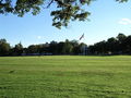 Salem Common in 2006 |
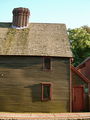 The Pickman House, c. 1664, located on Charter Street and believed to be Salem's oldest surviving building |
Notable residents
- Nehemiah Adams, clergyman & author
- Brunonia Barry, author of The Lace Reader
- Frank W. Benson, artist
- John Prentiss Benson, artist
- Bob Villa, craftsman
- William Bentley, Unitarian Minister, Salem diarist
- Nathaniel Bowditch, mathematician and navigator
- Rick Brunson, former NBA player
- Robert Ellis Cahill, sheriff, historian and author
- Laurie Cabot, Wiccan high priestess
- Roger Conant, founder of Salem
- Crowninshield family, Boston Brahmins who later helped settle Salem
- Elias Hasket Derby, merchant, first millionaire [19]
- Joseph Horace Eaton, artist and military officer
- John Endecott, governor
- Thomas Gardner (planter), co-founder of Salem
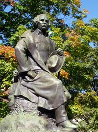
- Nathaniel Hawthorne, writer
- Jeff Juden, major league baseball pitcher
- Frederick W. Lander, Civil War General, wagon trail and railroad surveyor, poet
- John Larch, actor (1914–2005),
- Dudley Leavitt (1720–62), early Harvard-educated Congregational minister,[20] New Hampshire native, married to Mary Pickering,[21] Salem's Leavitt Street named for him [22]
- Mary Lou Lord singer/songwriter grew up in Salem
- Samuel McIntire, architect & woodcarver
- Charles Grafton Page, inventor
- George Swinton Parker, founder of Parker Brothers
- Samuel Parris, minister
- Timothy Pickering, secretary of state
- Benjamin Pickman, early Salem merchant for whom Salem's Pickman Street is named [23]
- Dudley Leavitt Pickman, (1779–1846), state legislator,[24] Salem merchant, partner, Devereux, Pickman & Silsbee,[25] wealthiest Salem merchant of his day [26][27]
- Sarah Parker Remond, abolitionist
- Aaron Richmond, impresario and artist manager
- Samuel Sewall, magistrate
- Brian St. Pierre, QB for the Arizona Cardinals
- Roger Williams, theologian
- Steve Thomas, former host of PBS's "This Old House"
- Jack Welch, former chairman and CEO of General Electric grew up in Salem, attended Salem High School
Sister cities
Further reading
- In the Devil's Snare: The Salem Witchcraft Crisis of 1692, Mary Beth Norton, Knopf, 2002, hardcover, 432 pages, ISBN 0-375-40709-X
Notes
- ↑ "Find a County". National Association of Counties. http://www.naco.org/Template.cfm?Section=Find_a_County&Template=/cffiles/counties/usamap.cfm. Retrieved 2008-01-31.
- ↑ Richard Gildrie, Salem Massachusetts 1626-1683, 4.
- ↑ Albert Christophe. The Romantic Story of the Puritan Fathers: And Their Founding of NewBoston. http://books.google.com/books?id=648_AAAAMAAJ&pg=PA131&lpg=PA131&dq=dorothy+talbye&source=web&ots=3yh_eFoua8&sig=gTpgLoNymx_uf9umOuCnSXtz19o#PPR5,M1. Retrieved 2007-11-14.
- ↑ The Loyalists of Massachusetts and the Other Side of the American Revolution, James H. Stark, James H. Stark, Boston, 1910
- ↑ John Fraylor. Salem Maritime National Historic Park http://www.nps.gov/revwar/about_the_revolution/privateers.html
- ↑ Salem history
- ↑ "US Gazetteer files: 2000 and 1990". United States Census Bureau. 2005-05-03. http://www.census.gov/geo/www/gazetteer/gazette.html. Retrieved 2008-01-31.
- ↑ "Census". United States Census. http://www2.census.gov/prod2/decennial/documents/1850a-02.pdf. page 36
- ↑ Campbell Gibson. "Population of the 100 largest cities and other urban places in the United States: 1790 to 1990". United States Bureau of the Census. http://www.census.gov/population/www/documentation/twps0027/twps0027.html.
- ↑ "American FactFinder". United States Census Bureau. http://factfinder.census.gov. Retrieved 2008-01-31.
- ↑ Salem News
- ↑ Salem News
- ↑ Salem News
- ↑ Harpies Bizarre
- ↑ Salem News
- ↑ [1]
- ↑ Laidler, John (April 26, 2009). "Work to start on old jail". The Boston Globe. http://www.boston.com/news/local/articles/2009/04/26/work_to_start_on_old_jail/.
- ↑ [2]
- ↑ Hasket Derby Pickman, Harvard College class of 1815 and son of Col. Benjamin Pickman Esq. and his wife Anstiss Derby, daughter of merchant Elias Hasket Derby and his wife Elizabeth Crowninshield, died the year he graduated from Harvard.[3]
- ↑ The Native Ministry of New Hampshire, Nathan Franklin Carter, Rumford Printing Co., Concord, N.H., 1906
- ↑ The Life of Timothy Pickering, Vol. II, Octavius Pickering, Charles Wentworth Upham, Little, Brown & Co., Boston, 1873
- ↑ Leavitt was minister of a splinter church of Salem's First Church. Upon Leavitt's untimely death in 1762, the church elected to call itself 'the Church of which the Rev. Mr. Dudley Leavitt was late Pastor.'[4]
- ↑ Naturalization papers of Benjamin Pickman, Dudley Leavitt Pickman Papers, Phillips Library Collection, Peabody Essex Museum, pem.org/museum
- ↑ Acts and Resolves Passed by the General Court, Russell, Cutler & Co., Boston, 1812-1815
- ↑ George Nichols, Salem Shipmaster and Merchant, George Nichols, Martha Nichols, Reprinted by Ayers Publishing, 1970
- ↑ Yankee India: American Commercial and Cultural Encounters with India in the Age of Sail, 1784–1860, Susan S. Bean, Peabody Essex Museum, Published by Peabody Essex Museum, 2001
- ↑ History of Essex County, Massachusetts, Vol. I, Douglas Hamilton Hurd, J.W. Lewis & Co., Philadelphia, 1888
- ↑ Chico considers establishing permanent sister city guidelines - Chico Enterprise Record
- ↑ This resulted from the affiliation between Salem's Peabody Essex Museum (PEM) and the Ota Folk Museum in Japan.
References
- Perley, Sidney. History of Salem, Massachusetts in Three Volumes. Full images at University of Virginia eText Center and the Salem Witch Trial Documentary Archive and Transcription Project.
- 1795 Map of Salem.
- Saunders, Jonathan P. 1832 Map of Salem.
- Beer, D.G. 1872 Atlas of Essex County Map of Salem. Plate 118.
- Walker, George H. 1884 Atlas of Essex County Salem South. Plate 16. Salem-Jail-to-hold-first-open-houseSalem North. Plate 17.
- Various Salem Atlases.
- Hopkins, C.M. Atlas of Salem, Massachusetts. Published in 1874.
- Sanborn Map Co. Map of Salem Showing Area Destroyed by Fire June 25, 1914.
- Atlas of Salem for 1890-1903 Index Map. Page selection.
- 1897 Atlas of Salem Massachusetts Index Map.
- Walker. 1911 Atlas of Salem, Massachusetts.
- Salem 1906-1938 Index or Key Map.
- Vital Records of Salem, Massachusetts to 1849. Published 1916, 1918, 1924, 1925. Transcribed and put online by John Slaugher.
External links
- City of Salem
- A multimedia walking tour of Salem
- Salem Public Library
- The First Church in Salem
- SalemWeb
- Salem Police Department
- Stephen Phillips Memorial Trust House
- This Week in Salem History
- History of the Salem Common
- The Bewitched Statue of Salem MA
- Salem Old Town Hall
- Salem Pioneer Village
|
||||||||||||||||
|
|||||||||||||||||